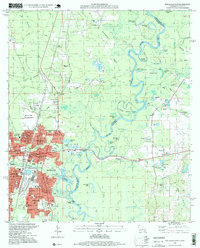
1997 Map of Bogalusa East
USGS Topo · Published 1999About this map
The Pearl River forms a wide, meandering boundary between Louisiana and Mississippi, creating a landscape of oxbow lakes and islands including Hamp Island and Big Eddy Lake. Along the western bank, the city of Bogalusa is defined by its industrial roots and a dense network of civic institutions. Educational and social landmarks are particularly prominent, ranging from the Sullivan Voc-Tech Inst and Sullivan Memorial Trade Sch to numerous neighborhood campuses like the Byrd Avenue Sch and North Side Sch.
Find a feature on this map
82 named features on this map. Tap any name to fly to it.
Don’t see what you’re looking for? This feature index may not catch every label — zoom into the map to look around manually.
Map Details
Editions of this 1997 Bogalusa East Map
This is the sole edition of this map. No revisions or reprints were ever made.
Other maps of this area

1942 · Rio
USGS Topo · 1:31,680

1942 · Pools Bluff
USGS Topo · 1:31,680

1949 · Bogalusa East
USGS Topo · 1:31,680

1949 · Angie
USGS Topo · 1:31,680

1949 · Bogalusa West
USGS Topo · 1:31,680

1950 · Crains Creek
USGS Topo · 1:31,680

1953 · Mobile
USGS Topo · 1:250,000

1957 · Mobile
USGS Topo · 1:250,000

1958 · Picayune
USGS Topo · 1:62,500

1959 · Bogalusa
USGS Topo · 1:62,500