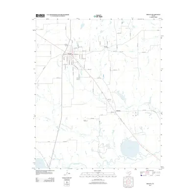
2013 Map of Bogata
USGS Topo · Published 2013About this map
The town of Bogata serves as the central hub of this Northeast Texas landscape, where local streets like Halesboro St and Roachtown Rd define the community layout. To the east and southeast, smaller settlements such as Rosalie and Johntown anchor the rural territory between significant water bodies. The hydrology of the region is dominated by the Sulphur River along the southern border and the expansive River Crest Reservoir, which stands as a prominent geographic feature in the southeast corner.
Find a feature on this map
73 named features on this map. Tap any name to fly to it.
Don’t see what you’re looking for? This feature index may not catch every label — zoom into the map to look around manually.
Map Details
Editions of this 2013 Bogata Map
This is the sole edition of this map. No revisions or reprints were ever made.
Other maps of this area

1953 · Texarkana
USGS Topo · 1:250,000

1956 · Texarkana
USGS Topo · 1:250,000

1963 · Mitchell Creek
USGS Topo · 1:24,000

1963 · Cunningham
USGS Topo · 1:24,000

1964 · Deport
USGS Topo · 1:24,000

1964 · Cuthand
USGS Topo · 1:24,000

1964 · Talco
USGS Topo · 1:24,000

1964 · Hagansport
USGS Topo · 1:24,000

1964 · Bogata
USGS Topo · 1:24,000
1964 · Line Branch
USGS Topo · 1:24,000