
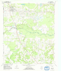
1964 Map of Talco
USGS Topo · Published 1967About this map
The Talco Oil Field dominates this mid-1960s landscape, illustrating the industrial footprint of petroleum extraction in East Texas. The town of Talco serves as the primary hub, where local infrastructure includes a High Sch, Water Tank, and the Talco Rodeo Ground. The map reveals a transition from these industrial and residential zones into the densely wooded bottomlands of White Oak Creek and Big Slough.
Find a feature on this map
25 named features on this map. Tap any name to fly to it.
Don’t see what you’re looking for? This feature index may not catch every label — zoom into the map to look around manually.
Map Details
Editions of this 1964 Talco Map
2 editions found
Other maps of this area

1953 · Texarkana
USGS Topo · 1:250,000

1956 · Texarkana
USGS Topo · 1:250,000

1964 · Mount Vernon
USGS Topo · 1:24,000

1964 · Cuthand
USGS Topo · 1:24,000

1964 · Wilkinson
USGS Topo · 1:24,000

1964 · Hagansport
USGS Topo · 1:24,000

1964 · Bogata
USGS Topo · 1:24,000

1965 · Winfield
USGS Topo · 1:24,000

1965 · Mount Pleasant
USGS Topo · 1:24,000
1965 · Boxelder
USGS Topo · 1:24,000