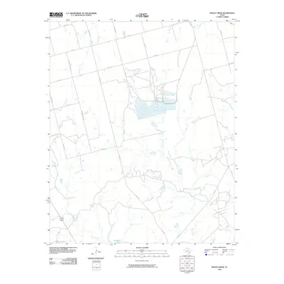
2010 Map of Boggy Creek
USGS Topo · Published 2010About this map
Boggy Creek and its complex network of drainage tributaries define the landscape of this portion of Wilbarger County. The area is characterized by a sparse, rural road grid that includes Carpenter-Duffie Rd and several farm-to-market routes like FM 433 E and FM 3430. A significant concentration of industrial or agricultural infrastructure is visible near the center of the sheet, where specialized containment structures and ponds sit adjacent to the creek. The presence of features like Stone Tank and Flax Tank near Turkey Creek highlights the local importance of water management in this cattle and ranching region of North Texas. Genealogists and researchers can trace the movement of early families and land use patterns through the named ranch roads and the meandering paths of Plum Creek and Dugan Creek.
Find a feature on this map
23 named features on this map. Tap any name to fly to it.
Don’t see what you’re looking for? This feature index may not catch every label — zoom into the map to look around manually.
Map Details
Editions of this 2010 Boggy Creek Map
This is the sole edition of this map. No revisions or reprints were ever made.
Other maps of this area

1954 · Wichita Falls
USGS Topo · 1:250,000

1955 · Lawton
USGS Topo · 1:250,000

1958 · Wichita Falls
USGS Topo · 1:250,000

1958 · Davidson
USGS Topo · 1:62,500

1958 · Vernon
USGS Topo · 1:62,500

1966 · Santa Rosa Lake
USGS Topo · 1:24,000

1966 · Grayback
USGS Topo · 1:24,000
1966 · Lake Electra
USGS Topo · 1:24,000
1983 · Boggy Creek
USGS Topo · 1:24,000
1983 · Lockett
USGS Topo · 1:24,000