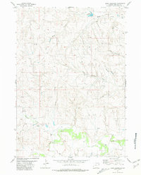
1981 Map of Boggy Reservoir
USGS Topo · Published 1981About this map
Lance Creek and its complex network of tributaries define this landscape in Niobrara County, Wyoming, as it appeared in the mid-1970s. The terrain is marked by numerous ephemeral drainages including Marcus Draw, Dogie Creek, and both the North Greasewood Creek and South Greasewood Creek. The primary water management feature is Boggy Reservoir, situated along Boggy Creek in the northeastern section of the quadrangle. Energy exploration and land management are evident through the numerous labels for Wells and Drill Holes scattered across the township and range lines. A remote Landing Strip south of the Greasewood drainages provides a key piece of infrastructure for this sparsely populated ranching and mineral-producing region.
Find a feature on this map
12 named features on this map. Tap any name to fly to it.
Don’t see what you’re looking for? This feature index may not catch every label — zoom into the map to look around manually.
Map Details
Editions of this 1981 Boggy Reservoir Map
This is the sole edition of this map. No revisions or reprints were ever made.
Other maps of this area

1955 · Newcastle
USGS Topo · 1:250,000

1958 · Newcastle
USGS Topo · 1:250,000

1981 · Horseshoe Bend
USGS Topo · 1:24,000

1981 · Threemile Butte
USGS Topo · 1:24,000

1981 · Dixon Ranch
USGS Topo · 1:24,000

1981 · Lance Creek NW
USGS Topo · 1:24,000
1981 · Funny Rock
USGS Topo · 1:24,000
1981 · Buck Creek Hills
USGS Topo · 1:24,000

1981 · Garland Draw
USGS Topo · 1:24,000
1981 · Greasewood Creek
USGS Topo · 1:24,000