
1958 Map of Boise
USGS Topo · Published 1958About this map
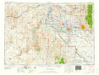
The Union Pacific railroad corridor anchors the agricultural and urban heart of the Treasure Valley in the late 1950s, connecting Idaho's growing capital at Boise with the industrial hubs of Nampa and Caldwell. The landscape transitions from the irrigated fields near the Boise River and Lake Lowell to the high desert and mountain terrain of the Mahogany Mountains and War Eagle Mountain. To the south and west, the vast river system defined by the Snake River and Owyhee River reveals a network of remote outposts like Jordan Valley and the site of Rockville (Abandoned). Mapping of the region is oriented by Initial Point, the fundamental survey marker for the state. Significant water management and conservation efforts are evident through the Deer Flat National Wildlife Refuge and large-scale infrastructure such as Swan Falls and the C. J. Strike Reservoir.
Find a feature on this map
111 named features on this map. Tap any name to fly to it.
Don’t see what you’re looking for? This feature index may not catch every label — zoom into the map to look around manually.
Map Details
Editions of this 1958 Boise Map
2 editions found
Other maps of this area

1892 · Mountain Home
USGS Topo · 1:125,000

1892 · Boise
USGS Topo · 1:125,000

1892 · Bisuka
USGS Topo · 1:125,000

1892 · Silver City
USGS Topo · 1:125,000

1893 · Mountain Home
USGS Topo · 1:125,000

1894 · Bisuka
USGS Topo · 1:125,000

1894 · Silver City
USGS Topo · 1:125,000

1894 · Squaw Creek
USGS Topo · 1:125,000

1894 · Idaho Basin
USGS Topo · 1:125,000

1897 · Boise
USGS Topo · 1:125,000