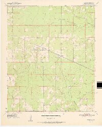
1951 Map of Bokhoma
USGS Topo · Published 1951About this map
Bokhoma and the nearby community of Moon are central features of this McCurtain County landscape at the dawn of the 1950s. The region is defined by a dense network of watercourses, including the various branches of North Caney Creek and the meandering Parker Creek. Local life is anchored by several rural institutions such as the Oak Ridge Sch and Choctaw Ch, providing clear points of reference for genealogists and local historians studying mid-century Oklahoma. The St Louis San Francisco railroad cuts diagonally across the center of the survey, passing through the settlement of America. This transportation corridor, paired with the scattered rural homes and the Bokhoma Cem, illustrates a community deeply tied to both the land and the rail infrastructure of the era.
Find a feature on this map
18 named features on this map. Tap any name to fly to it.
Don’t see what you’re looking for? This feature index may not catch every label — zoom into the map to look around manually.
Map Details
Editions of this 1951 Bokhoma Map
2 editions found
Other maps of this area

1950 · De Kalb NW
USGS Topo · 1:24,000

1950 · Shults
USGS Topo · 1:24,000

1950 · Haworth
USGS Topo · 1:24,000

1950 · Tom
USGS Topo · 1:24,000

1950 · Goodwater
USGS Topo · 1:24,000

1950 · Bokhoma
USGS Topo · 1:24,000

1951 · De Kalb NW
USGS Topo · 1:24,000

1951 · Haworth
USGS Topo · 1:24,000

1951 · Tom
USGS Topo · 1:24,000

1951 · Bokhoma
USGS Topo · 1:24,000