
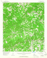
1956 Map of Bolingbroke
USGS Topo · Published 1957About this map
Montpelier Institute stands as a focal point in the rolling middle Georgia landscape, situated near the intersection of Monroe and Bibb counties. This mid-century survey captures a network of rural communities connected by the Central of Georgia Railroad and historical routes like the Dixie Highway. The region is defined by numerous small congregations and educational sites, including the Rosenwald Sch, reflecting the importance of community centers in the post-war South. Waterways such as Tobesofkee Creek and Echeconnee Creek carve through the terrain, while settlements like Bolingbroke and Smarr anchor the northern rail line. From the Girl Scout grounds at Camp Martha Johnston to the scattered schools like Redding Sch, the map reveals a deeply established social fabric of family-named landmarks and rural institutions.
Find a feature on this map
90 named features on this map. Tap any name to fly to it.
Don’t see what you’re looking for? This feature index may not catch every label — zoom into the map to look around manually.
Map Details
Editions of this 1956 Bolingbroke Map
2 editions found
Other maps of this area

1951 · Yatesville
USGS Topo · 1:62,500

1951 · Forsyth
USGS Topo · 1:62,500

1951 · Barnesville
USGS Topo · 1:62,500

1953 · Atlanta
USGS Topo · 1:250,000

1953 · Athens
USGS Topo · 1:250,000

1955 · Phenix City
USGS Topo · 1:250,000

1956 · Fort Valley
USGS Topo · 1:62,500

1956 · Warner Robins
USGS Topo · 1:62,500

1956 · Macon West
USGS Topo · 1:24,000

1956 · Macon
USGS Topo · 1:62,500