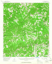
1956 Map of Bolingbroke
USGS Topo · Published 1965About this map
The Central of Georgia Railroad carves a path through the northeastern corner of this landscape, anchoring the village of Bolingbroke. The terrain is defined by a dense network of tributaries including Tobesofkee Creek and Echeconnee Creek, which cross the boundaries between Monroe, Bibb, and Crawford counties. This mid-century survey reveals a rural community deeply connected by its institutions, featuring numerous country churches like Salem Ch and St Paul Ch, alongside the Johns Chapel Ch and school.
Find a feature on this map
62 named features on this map. Tap any name to fly to it.
Don’t see what you’re looking for? This feature index may not catch every label — zoom into the map to look around manually.
Map Details
Editions of this 1956 Bolingbroke Map
2 editions found
Other maps of this area

1951 · Yatesville
USGS Topo · 1:62,500

1951 · Forsyth
USGS Topo · 1:62,500

1951 · Barnesville
USGS Topo · 1:62,500

1953 · Atlanta
USGS Topo · 1:250,000

1953 · Athens
USGS Topo · 1:250,000

1955 · Phenix City
USGS Topo · 1:250,000

1956 · Fort Valley
USGS Topo · 1:62,500

1956 · Bolingbroke
USGS Topo · 1:62,500

1956 · Warner Robins
USGS Topo · 1:62,500

1956 · Macon West
USGS Topo · 1:24,000