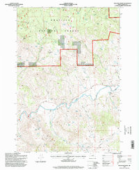
1995 Map of Bologna Basin
USGS Topo · Published 1998About this map
Bologna Basin and the surrounding drainages of the Umatilla National Forest dominate this mid-1990s survey of Grant County. The landscape is defined by the deep incisions of Bologna Canyon and Portuguese Canyon, which channel water toward the North Fork John Day River. This confluence point represents a critical hydrological junction in the high desert, where the river's path is reinforced by a levee system near BM 1950.
Find a feature on this map
28 named features on this map. Tap any name to fly to it.
Don’t see what you’re looking for? This feature index may not catch every label — zoom into the map to look around manually.
Map Details
Editions of this 1995 Bologna Basin Map
This is the sole edition of this map. No revisions or reprints were ever made.
Other maps of this area

1951 · Courtrock
USGS Topo · 1:62,500

1951 · Monument
USGS Topo · 1:62,500

1953 · Kimberly
USGS Topo · 1:62,500

1953 · Picture
USGS Topo · 1:62,500

1955 · Canyon City
USGS Topo · 1:250,000

1959 · Canyon City
USGS Topo · 1:250,000

1980 · Monument
USGS Topo · 1:100,000
1990 · Monument
USGS Topo · 1:24,000
1990 · Miller Flat
USGS Topo · 1:24,000
1990 · Bologna Basin
USGS Topo · 1:24,000