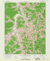
1953 Map of Boltsfork
USGS Topo · Published 1967About this map
The East Fork Little Sandy River meanders through this portion of Boyd and Lawrence Counties, where the mid-century landscape is defined by the narrow valleys of the Cumberland Plateau. Small farming and mining communities like Mavity and Alley anchor the hollows, connected by winding roads that track the path of Bolts Fork and Trace Creek. The 1953 field survey documents a community infrastructure built around family names and rural institutions, featuring numerous family plots such as the Robinette Cem and Hamilton Cem. Significant industrial activity is visible in the north with a mapped Strip Mine, while the southern reaches near Boltsfork show the early footprint of the Gas Field. This era represents a time before modern highway expansion, when local life centered on landmarks like Grassland Ch and Ararat Sch.
Find a feature on this map
66 named features on this map. Tap any name to fly to it.
Don’t see what you’re looking for? This feature index may not catch every label — zoom into the map to look around manually.
Map Details
Editions of this 1953 Boltsfork Map
2 editions found
Other maps of this area

1901 · Ceredo
USGS Topo · 1:62,500

1903 · Kenova
USGS Topo · 1:125,000

1904 · Kenova
USGS Topo · 1:125,000

1911 · Louisa
USGS Topo · 1:48,000

1913 · Ceredo
USGS Topo · 1:62,500

1913 · Louisa
USGS Topo · 1:62,500

1939 · Louisa
USGS Topo · 1:62,500
1953 · Prichard
USGS Topo · 1:24,000

1953 · Rush
USGS Topo · 1:24,000

1953 · Boltsfork
USGS Topo · 1:24,000