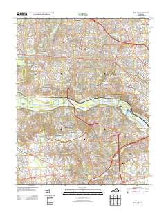
2013 Map of Bon Air
USGS Topo · Published 2013About this map
The James River and the historic James River and Kanawha Canal define the central landscape of this Richmond-area survey, bisecting a region of rapid suburban expansion and established neighborhood enclaves. On the north bank, the map documents the dense residential layouts of Gayton and Canterbury, while the south bank features a network of smaller communities such as Mount Nebo, Robious, and Brighton Green. The river itself is punctuated by Tuckahoe Island and Williams Island, with the Huguenot Memorial Bridge serving as a primary transit link. To the south, the landscape is marked by smaller water features like Rock Creek Park Lake and the Girl Scout Camp, illustrating the blend of recreational spaces and residential development in Henrico and Chesterfield counties during the early 21st century.
Find a feature on this map
113 named features on this map. Tap any name to fly to it.
Don’t see what you’re looking for? This feature index may not catch every label — zoom into the map to look around manually.
Map Details
Editions of this 2013 Bon Air Map
This is the sole edition of this map. No revisions or reprints were ever made.
Other maps of this area

1890 · Goochland
USGS Topo · 1:125,000

1892 · Goochland
USGS Topo · 1:125,000

1894 · Bermuda Hundred
USGS Topo · 1:62,500

1894 · Richmond
USGS Topo · 1:62,500

1895 · Richmond
USGS Topo · 1:62,500

1897 · Amelia
USGS Topo · 1:125,000

1934 · Richmond
USGS Topo · 1:24,000

1936 · Richmond West
USGS Topo · 1:24,000

1936 · Glen Allen
USGS Topo · 1:24,000

1938 · Drewrys Bluff
USGS Topo · 1:24,000