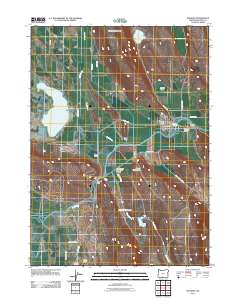
2011 Map of Bonanza
USGS Topo · Published 2011About this map
Bonanza serves as the focal point of this Klamath County landscape, situated where the Lost River bends through the junction of Yonna Valley and Langell Valley. The map illustrates a region defined by its water management and agricultural infrastructure, featuring the Yonna Ditch and Harpold Dam. Rural life is centered around longstanding landmarks like the Bonanza Post Office and the Bonanza Memorial Park, while outlying areas are marked by family-named infrastructure such as Lytle Pump and Dairy Pump. To the south, the Bedfield Cemetery and Seven Springs Ranch provide points of interest for genealogists tracing early settlement patterns. The terrain transitions from the seasonal waters of Alkali Lake and Short Lake to the higher elevations of Short Lake Mountain, showing a complex network of ranch roads and specialized sites like the Compressor Station 14 Airstrip.
Find a feature on this map
34 named features on this map. Tap any name to fly to it.
Don’t see what you’re looking for? This feature index may not catch every label — zoom into the map to look around manually.
Map Details
Editions of this 2011 Bonanza Map
This is the sole edition of this map. No revisions or reprints were ever made.
Other maps of this area

1889 · Klamath
USGS Topo · 1:250,000

1894 · Klamath
USGS Topo · 1:250,000

1955 · Klamath Falls
USGS Topo · 1:250,000

1957 · Merrill
USGS Topo · 1:62,500

1957 · Swan Lake
USGS Topo · 1:62,500

1957 · Malin
USGS Topo · 1:62,500

1958 · Klamath Falls
USGS Topo · 1:250,000

1960 · Beatty
USGS Topo · 1:62,500
1985 · Dairy
USGS Topo · 1:24,000
1985 · Swan Lake
USGS Topo · 1:24,000