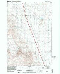
1997 Map of Bond
USGS Topo · Published 2002About this map
Bond and its surrounding water infrastructure define this high-elevation landscape in Beaverhead County. The complex network of irrigation and water management is evident through features like the Beaverhead Water Company Ditch, Willow Creek Ditch, and the West Side Canal. These man-made channels contrast with natural terrain features such as Cave Gulch and Frying Pan Gulch. The reliance on water storage for ranching or agriculture in this arid environment is reflected in the placement of Blomquist Reservoir and Overnight Reservoir. Local transit and land division are anchored by Anderson Lane, while industrial activity is noted at a Gravel Pit near the center of the sheet. The layout of Guidici Ditch and Murray Ditch further illustrates how early-twentieth-century water rights shaped the development of this Montana valley.
Find a feature on this map
17 named features on this map. Tap any name to fly to it.
Don’t see what you’re looking for? This feature index may not catch every label — zoom into the map to look around manually.
Map Details
Editions of this 1997 Bond Map
This is the sole edition of this map. No revisions or reprints were ever made.
Other maps of this area

1893 · Dillon
USGS Topo · 1:250,000

1952 · Twin Adams Mountain
USGS Topo · 1:24,000

1952 · Argenta
USGS Topo · 1:24,000

1952 · Burns Mountain
USGS Topo · 1:24,000

1955 · Dillon
USGS Topo · 1:250,000

1957 · Dillon
USGS Topo · 1:250,000

1958 · Dillon
USGS Topo · 1:250,000

1960 · Glen
USGS Topo · 1:24,000

1960 · Block Mountain
USGS Topo · 1:24,000

1961 · Glen SE
USGS Topo · 1:24,000