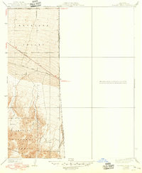
1939 Map of Boneyard Canyon
USGS Topo · Published 1949About this map
The San Gabriel Mountains dominate this 1930s landscape, where the northern slopes of the Angeles National Forest meet the southern edge of the Antelope Valley. This era shows a transition from high-altitude drainages like Jesus Canyon and Puzzle Canyon to the flatter desert roads of the valley floor. The Jubilee Ranch sits as a lonely outpost at the base of the mountains, illustrating the early ranching footprint in the high desert before extensive modern development. Surveyed in 1934 with cultural updates from 1948, the map documents a network of historic thoroughfares, including the Palmdale Victorville Road and Fort Tejon Road. These routes provided critical connections between the desert basins and mountain passes. Small-scale water features like the Reservoir and seasonal flows of Canyon Creek reveal the constant effort to manage water in this arid Los Angeles and San Bernardino county border region.
Find a feature on this map
19 named features on this map. Tap any name to fly to it.
Don’t see what you’re looking for? This feature index may not catch every label — zoom into the map to look around manually.
Map Details
Editions of this 1939 Boneyard Canyon Map
2 editions found
Other maps of this area

1901 · Southern California Sheet No. 1
USGS Topo · 1:250,000

1903 · San Antonio
USGS Topo · 1:62,500

1904 · Southern California Sheet No. 1
USGS Topo · 1:250,000

1930 · Black Butte
USGS Topo · 1:24,000

1930 · Angle
USGS Topo · 1:24,000

1932 · Angle
USGS Topo · 1:24,000

1933 · Black Butte
USGS Topo · 1:24,000

1934 · Mescal Creek
USGS Topo · 1:24,000
1934 · Boneyard Canyon
USGS Topo · 1:24,000
1936 · Mt. Baden-Powell
USGS Topo · 1:24,000