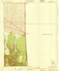
1939 Map of Boneyard Canyon
USGS Topo · Published 1939About this map
The Los Angeles Co San Bernardino Co border runs directly through this 1930s survey, marking the transition from the high desert floor of the Antelope Valley into the steep northern slopes of the San Gabriel Mountains. This landscape is defined by the dramatic ascent from the arid basin into the protected lands of the Angeles National Forest, where deep drainages like Boneyard Canyon and Puzzle Canyon carve into the mountain front.
Find a feature on this map
14 named features on this map. Tap any name to fly to it.
Don’t see what you’re looking for? This feature index may not catch every label — zoom into the map to look around manually.
Map Details
Editions of this 1939 Boneyard Canyon Map
2 editions found
Other maps of this area

1901 · Southern California Sheet No. 1
USGS Topo · 1:250,000

1903 · San Antonio
USGS Topo · 1:62,500

1904 · Southern California Sheet No. 1
USGS Topo · 1:250,000

1930 · Black Butte
USGS Topo · 1:24,000

1930 · Angle
USGS Topo · 1:24,000

1932 · Angle
USGS Topo · 1:24,000

1933 · Black Butte
USGS Topo · 1:24,000

1934 · Mescal Creek
USGS Topo · 1:24,000
1934 · Boneyard Canyon
USGS Topo · 1:24,000
1936 · Mt. Baden-Powell
USGS Topo · 1:24,000