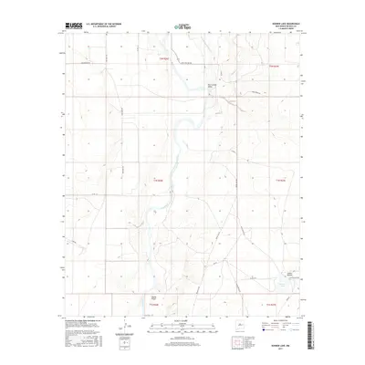
2017 Map of Bonner Lake
USGS Topo · Published 2017About this map
The Pecos River snakes through the heart of this De Baca County landscape, defining the agricultural character of the Fort Sumner Valley. This 2017 survey illustrates a sophisticated desert irrigation network where the Fort Sumner Main Canal and Taiban Cr support local ranching and farming operations. The terrain transitions from the river's riparian corridor to the elevated heights of Mesita Negra and the dramatic relief of Cañon Blanco in the southeast corner.
Find a feature on this map
27 named features on this map. Tap any name to fly to it.
Don’t see what you’re looking for? This feature index may not catch every label — zoom into the map to look around manually.
Map Details
Editions of this 2017 Bonner Lake Map
This is the sole edition of this map. No revisions or reprints were ever made.
Other maps of this area

1954 · Fort Sumner
USGS Topo · 1:250,000

1958 · Fort Sumner
USGS Topo · 1:250,000

1965 · Fort Sumner West
USGS Topo · 1:24,000

1966 · Alamo Ranch
USGS Topo · 1:24,000

1967 · Eighteenmile Hill
USGS Topo · 1:24,000
1967 · Conejo Creek East
USGS Topo · 1:24,000
1967 · Watts Hill
USGS Topo · 1:24,000

1968 · Lomas Gatos
USGS Topo · 1:24,000

1968 · Fort Sumner East
USGS Topo · 1:24,000

1968 · Taiban
USGS Topo · 1:24,000