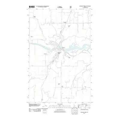
2011 Map of Bonners Ferry
USGS Topo · Published 2011About this map
The Kootenai River defines the geography of this northern Idaho landscape, winding past the community of Bonners Ferry. The town serves as a hub for the surrounding rural settlements, including Schnoors and Threemile Corner. The map reveals a distinct pattern of valley floor development and agricultural layout, specifically within Paradise Valley. Notable family and local landmarks are preserved in the positioning of O'Callaghans Island and Allens Spur.
Find a feature on this map
53 named features on this map. Tap any name to fly to it.
Don’t see what you’re looking for? This feature index may not catch every label — zoom into the map to look around manually.
Map Details
Editions of this 2011 Bonners Ferry Map
This is the sole edition of this map. No revisions or reprints were ever made.
Other maps of this area

1911 · Priest Lake
USGS Topo · 1:250,000

1913 · Priest Lake
USGS Topo · 1:250,000

1958 · Sandpoint
USGS Topo · 1:250,000

1963 · Sandpoint
USGS Topo · 1:250,000

1965 · Meadow Creek
USGS Topo · 1:24,000

1965 · Farnham Peak
USGS Topo · 1:24,000

1965 · Twentymile Creek
USGS Topo · 1:24,000

1965 · Moravia
USGS Topo · 1:24,000

1965 · Ritz
USGS Topo · 1:24,000
1965 · Moyie Springs
USGS Topo · 1:24,000