
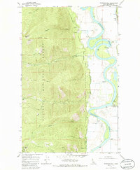
1965 Map of Farnham Peak
USGS Topo · Published 1967About this map
The Kootenai River meanders dramatically through this portion of Boundary County, Idaho, creating a sharp contrast between the flat, low-lying river bottom and the steep eastern slopes of the Kaniksu National Forest. In the mid-1960s, this landscape was defined by the intersection of mountain geography and river-valley infrastructure. Along the northeastern edge, the Great Northern railroad tracks parallel the river, supporting small industrial points like Camp 5 and a Grain Elevator.
Find a feature on this map
26 named features on this map. Tap any name to fly to it.
Don’t see what you’re looking for? This feature index may not catch every label — zoom into the map to look around manually.
Map Details
Editions of this 1965 Farnham Peak Map
2 editions found
Other maps of this area

1911 · Priest Lake
USGS Topo · 1:250,000

1913 · Priest Lake
USGS Topo · 1:250,000

1958 · Sandpoint
USGS Topo · 1:250,000

1963 · Sandpoint
USGS Topo · 1:250,000

1965 · Moravia
USGS Topo · 1:24,000

1965 · Ritz
USGS Topo · 1:24,000

1965 · Copeland
USGS Topo · 1:24,000

1965 · Hall Mountain
USGS Topo · 1:24,000
1965 · Bonners Ferry
USGS Topo · 1:24,000
1967 · Roman Nose
USGS Topo · 1:24,000