
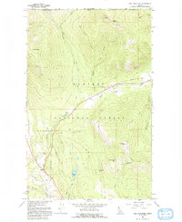
1965 Map of Hall Mountain
USGS Topo · Published 1967About this map
Kaniksu National Forest defines this borderland landscape in northern Idaho, where the international boundary separates Canada from the United States. The map reveals a mid-century terrain dominated by high-altitude resource extraction, including the American Girl Mine, Miller Brothers Mine, Bethlehem Mine, and Tungsten Hill Mine. These sites are linked by a network of primitive routes such as Mission Road, Pywell Road, and Deer Park Road, alongside numerous jeep trails used for forest management and mining access.
Find a feature on this map
34 named features on this map. Tap any name to fly to it.
Don’t see what you’re looking for? This feature index may not catch every label — zoom into the map to look around manually.
Map Details
Editions of this 1965 Hall Mountain Map
2 editions found
Other maps of this area

1911 · Priest Lake
USGS Topo · 1:250,000

1913 · Priest Lake
USGS Topo · 1:250,000

1958 · Sandpoint
USGS Topo · 1:250,000

1963 · Sandpoint
USGS Topo · 1:250,000

1965 · Meadow Creek
USGS Topo · 1:24,000

1965 · Farnham Peak
USGS Topo · 1:24,000

1965 · Eastport
USGS Topo · 1:24,000

1965 · Ritz
USGS Topo · 1:24,000

1965 · Copeland
USGS Topo · 1:24,000
1983 · Bonners Ferry
USGS Topo · 1:100,000