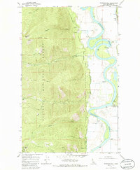
1965 Map of Farnham Peak
USGS Topo · Published 1985About this map
The Kootenai River snakes through the eastern valley of this Idaho panhandle region, defining the transition between low-lying agricultural floodplains and the steep ascent of the Kaniksu National Forest. In the mid-1960s, this landscape supported a mix of timber and agricultural operations, evidenced by Camp 5 and its associated Grain Elevator near the river. High-elevation landmarks like Farnham Peak and Burton Peak anchor the western terrain, where the Myrtle Creek State Game Preserve borders the rugged Russell Ridge. Human infrastructure is concentrated along the West Side Road and the riverbanks, where multiple Pumping Stations and a Gaging Station manage water resources. These details provide a clear picture of the land management and resource extraction patterns in Boundary County during this era.
Find a feature on this map
33 named features on this map. Tap any name to fly to it.
Don’t see what you’re looking for? This feature index may not catch every label — zoom into the map to look around manually.
Map Details
Editions of this 1965 Farnham Peak Map
2 editions found
Other maps of this area

1911 · Priest Lake
USGS Topo · 1:250,000

1913 · Priest Lake
USGS Topo · 1:250,000

1958 · Sandpoint
USGS Topo · 1:250,000

1963 · Sandpoint
USGS Topo · 1:250,000

1965 · Farnham Peak
USGS Topo · 1:24,000

1965 · Moravia
USGS Topo · 1:24,000

1965 · Ritz
USGS Topo · 1:24,000

1965 · Copeland
USGS Topo · 1:24,000

1965 · Hall Mountain
USGS Topo · 1:24,000
1965 · Bonners Ferry
USGS Topo · 1:24,000