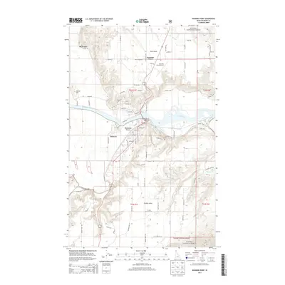
2013 Map of Bonners Ferry
USGS Topo · Published 2013About this map
The Kootenai River carves a broad arc through the center of this landscape, anchoring the city of Bonners Ferry and its surrounding agricultural and timber lands. This 2013 survey illustrates a developed riverfront where O'Callaghans Island sits just offshore from the downtown core. The town is flanked by distinct residential and rural clusters, including Mission Hill to the west and the upland plateau of North Bench to the north.
Find a feature on this map
91 named features on this map. Tap any name to fly to it.
Don’t see what you’re looking for? This feature index may not catch every label — zoom into the map to look around manually.
Map Details
Editions of this 2013 Bonners Ferry Map
This is the sole edition of this map. No revisions or reprints were ever made.
Other maps of this area

1911 · Priest Lake
USGS Topo · 1:250,000

1913 · Priest Lake
USGS Topo · 1:250,000

1958 · Sandpoint
USGS Topo · 1:250,000

1963 · Sandpoint
USGS Topo · 1:250,000

1965 · Meadow Creek
USGS Topo · 1:24,000

1965 · Farnham Peak
USGS Topo · 1:24,000

1965 · Twentymile Creek
USGS Topo · 1:24,000

1965 · Moravia
USGS Topo · 1:24,000

1965 · Ritz
USGS Topo · 1:24,000
1965 · Moyie Springs
USGS Topo · 1:24,000