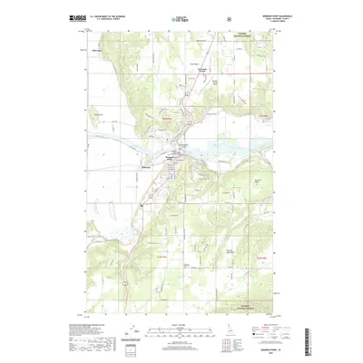
2020 Map of Bonners Ferry
USGS Topo · Published 2020About this map
Bonners Ferry serves as the focal point of this North Idaho landscape, situated along a pronounced bend of the Kootenai River. The town's grid is anchored by the Boundary County Courthouse and radiates outward toward the riverbanks and O'Callaghans Island. To the north, the terrain climbs toward North Bench and Threemile Corner, while the western edge is defined by the elevation of Mission Hill. The mapping of small settlements like Allens Spur and Schnoors reveals the historical distribution of activity along the river valley floor before the land rises sharply into the Cabinet Mountains and the protected timberlands of the Kaniksu National Forest. This 2020 data captures a modern perspective on a long-inhabited valley, where land use transitions from the municipal center of the county seat to the sprawling agricultural reaches of Paradise Valley. Notable for genealogists are the three distinct burial grounds: Grandview Cem, Paradise Valley Cem, and Moravia Cem.
Find a feature on this map
112 named features on this map. Tap any name to fly to it.
Don’t see what you’re looking for? This feature index may not catch every label — zoom into the map to look around manually.
Map Details
Editions of this 2020 Bonners Ferry Map
This is the sole edition of this map. No revisions or reprints were ever made.
Other maps of this area

1911 · Priest Lake
USGS Topo · 1:250,000

1913 · Priest Lake
USGS Topo · 1:250,000

1958 · Sandpoint
USGS Topo · 1:250,000

1963 · Sandpoint
USGS Topo · 1:250,000

1965 · Meadow Creek
USGS Topo · 1:24,000

1965 · Farnham Peak
USGS Topo · 1:24,000

1965 · Twentymile Creek
USGS Topo · 1:24,000

1965 · Moravia
USGS Topo · 1:24,000

1965 · Ritz
USGS Topo · 1:24,000
1965 · Moyie Springs
USGS Topo · 1:24,000