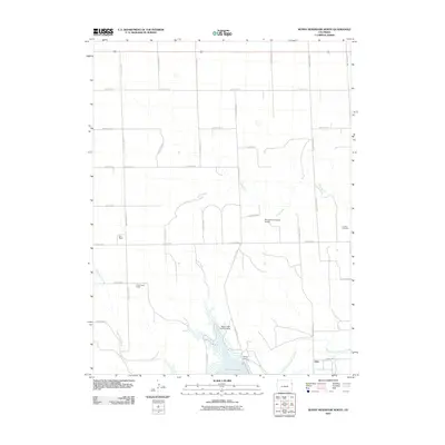
2010 Map of Bonny Reservoir North
USGS Topo · Published 2010About this map
Bonny Reservoir and the South Fork Republican River anchor the southern boundary of this landscape, where the waters are managed by the Bonny Dam and diverted through the Hale Ditch. The surrounding terrain in eastern Yuma County is defined by a rigorous grid of county roads that service isolated homesteads and livestock operations, including Burr Ranch and Moellenberg Ranch. This 2010 survey reflects a high-plains agricultural economy supported by small-scale aviation infrastructure, such as the M A and K A Dickson Airport and the Bonny Dam Landing Strip. For local historians and genealogists, the Downey Cemetery and the settlement of Hale represent important cornerstones of the community's heritage. The drainage patterns of Sand Creek and Armknecht Creek carve subtle relief into the otherwise orderly square-mile sections of the Colorado plains.
Find a feature on this map
33 named features on this map. Tap any name to fly to it.
Don’t see what you’re looking for? This feature index may not catch every label — zoom into the map to look around manually.
Map Details
Editions of this 2010 Bonny Reservoir North Map
This is the sole edition of this map. No revisions or reprints were ever made.
Other maps of this area

1950 · Bonny Reservoir
USGS Topo · 1:62,500

1954 · Limon
USGS Topo · 1:250,000

1957 · Limon
USGS Topo · 1:250,000

1958 · Limon
USGS Topo · 1:250,000

1963 · Beecher Island
USGS Topo · 1:24,000
1963 · Armel
USGS Topo · 1:24,000

1963 · Wildcat Canyon
USGS Topo · 1:24,000

1968 · Bonny Reservoir North
USGS Topo · 1:24,000

1968 · Idalia
USGS Topo · 1:24,000

1969 · Idalia SE
USGS Topo · 1:24,000