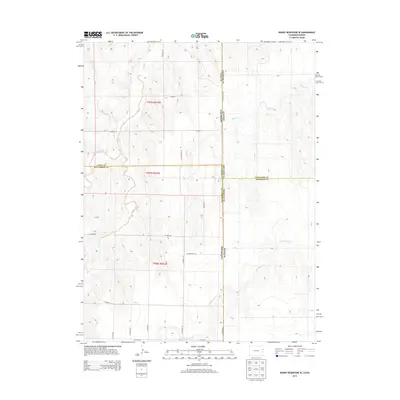
2013 Map of Bonny Reservoir SE
USGS Topo · Published 2013About this map
The High Plains borderlands where Colorado meets Kansas are defined here by a series of intermittent waterways carving through the agricultural grid. Hale Ditch and Bonny Creek dominate the northwest, while the southern reaches are marked by the complex drainage of Little Beaver Creek. This 2013 survey illustrates the precise intersection of four counties across the state line, where Yuma and Kit Carson counties in Colorado meet Cheyenne and Sherman counties in Kansas. The landscape is structured by a rigorous network of section lines and gravel routes such as CO Road 2 and CO Road 60, reflecting the enduring Public Land Survey System. The map provides a technical view of the region's topography, from the drainage of Battle Creek to the various farm-to-market roads that bind these rural communities together across state boundaries.
Find a feature on this map
30 named features on this map. Tap any name to fly to it.
Don’t see what you’re looking for? This feature index may not catch every label — zoom into the map to look around manually.
Map Details
Editions of this 2013 Bonny Reservoir SE Map
This is the sole edition of this map. No revisions or reprints were ever made.
Other maps of this area

1950 · Bonny Reservoir
USGS Topo · 1:62,500

1952 · St Francis 3
USGS Topo · 1:62,500

1954 · Limon
USGS Topo · 1:250,000

1954 · Goodland
USGS Topo · 1:250,000

1956 · Goodland
USGS Topo · 1:250,000

1957 · Limon
USGS Topo · 1:250,000

1957 · Goodland
USGS Topo · 1:250,000

1958 · Limon
USGS Topo · 1:250,000

1966 · Ruleton NW
USGS Topo · 1:24,000

1968 · Bonny Reservoir North
USGS Topo · 1:24,000