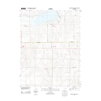
2013 Map of Bonny Reservoir South
USGS Topo · Published 2013About this map
Bonny Reservoir and its surrounding agricultural plains dominate this 2013 survey of the borderlands between Yuma and Kit Carson counties. Managed as part of Bonny State Park, the reservoir sits at the confluence of the South Fork Republican River and Armknecht Cr, serving as a critical water management point in this arid high-plains landscape. The intricate network of irrigation is visible through features like the Hale Ditch and the Hale Ditch Aqueduct, which channel water across the undulating terrain to support local ranching and farming operations.
Find a feature on this map
35 named features on this map. Tap any name to fly to it.
Don’t see what you’re looking for? This feature index may not catch every label — zoom into the map to look around manually.
Map Details
Editions of this 2013 Bonny Reservoir South Map
This is the sole edition of this map. No revisions or reprints were ever made.
Other maps of this area

1950 · Bonny Reservoir
USGS Topo · 1:62,500

1954 · Limon
USGS Topo · 1:250,000

1957 · Limon
USGS Topo · 1:250,000

1958 · Limon
USGS Topo · 1:250,000

1968 · Bonny Reservoir North
USGS Topo · 1:24,000

1968 · Idalia
USGS Topo · 1:24,000

1969 · Kanorado NE
USGS Topo · 1:24,000

1969 · Idalia SE
USGS Topo · 1:24,000

1969 · Kanorado NW
USGS Topo · 1:24,000
1969 · Burlington NE
USGS Topo · 1:24,000