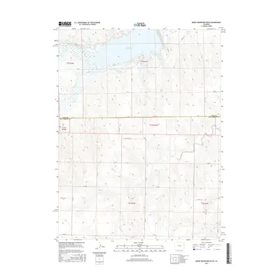
2016 Map of Bonny Reservoir South
USGS Topo · Published 2016About this map
Bonny Reservoir serves as the central focal point of this eastern Colorado landscape, where the South Fork Republican River and several local tributaries converge. The map illustrates a complex water management system essential for high plains agriculture, featuring the Hale Ditch and the smaller O'Brien Reservoir Number 1. These waterways, including Armknecht Cr and Landsman Cr, dictate the movement of roads and property lines across the terrain.
Find a feature on this map
35 named features on this map. Tap any name to fly to it.
Don’t see what you’re looking for? This feature index may not catch every label — zoom into the map to look around manually.
Map Details
Editions of this 2016 Bonny Reservoir South Map
This is the sole edition of this map. No revisions or reprints were ever made.
Other maps of this area

1950 · Bonny Reservoir
USGS Topo · 1:62,500

1954 · Limon
USGS Topo · 1:250,000

1957 · Limon
USGS Topo · 1:250,000

1958 · Limon
USGS Topo · 1:250,000

1968 · Bonny Reservoir North
USGS Topo · 1:24,000

1968 · Idalia
USGS Topo · 1:24,000

1969 · Kanorado NE
USGS Topo · 1:24,000

1969 · Idalia SE
USGS Topo · 1:24,000

1969 · Kanorado NW
USGS Topo · 1:24,000
1969 · Burlington NE
USGS Topo · 1:24,000