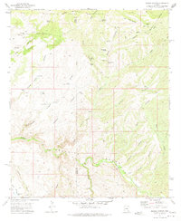
1972 Map of Booger Canyon
USGS Topo · Published 1975About this map
Aravaipa Canyon and its associated watercourse, Aravaipa Creek, dominate the southern landscape of this Arizona quadrangle, which spans the border of Pinal and Graham counties. The terrain is defined by a complex network of drainage systems, including Booger Canyon, Horse Canyon, and Black Canyon, many of which feed into the primary creek bed. The northern section is comprised of the San Carlos Indian Reservation, marked by significant landmarks like Lookout Mountain and Lone Cedar Mesa. Traces of human presence are scattered across this arid environment, ranging from an ancient Cliff Dwelling and various Ruins to more contemporary features like the Salazar Cem and several unnamed corrals. The mapping of numerous water sources—such as McKinney Spring, Black Canyon Spring, and Chet Tank—highlights the vital importance of water management for cattle and survival in this canyon-ribbed territory during the early 1970s.
Find a feature on this map
61 named features on this map. Tap any name to fly to it.
Don’t see what you’re looking for? This feature index may not catch every label — zoom into the map to look around manually.
Map Details
Editions of this 1972 Booger Canyon Map
2 editions found
Other maps of this area

1911 · Winkelman
USGS Topo · 1:125,000

1913 · Winkelman
USGS Topo · 1:125,000

1915 · Christmas
USGS Topo · 1:62,500

1917 · Christmas
USGS Topo · 1:62,500

1938 · Klondyke
USGS Topo · 1:48,000

1943 · Klondyke
USGS Topo · 1:62,500

1949 · Holy Joe Peak
USGS Topo · 1:62,500

1949 · Brandenburg Mtn
USGS Topo · 1:24,000
1949 · Holy Joe Peak
USGS Topo · 1:24,000
1950 · Brandenburg Mtn
USGS Topo · 1:24,000