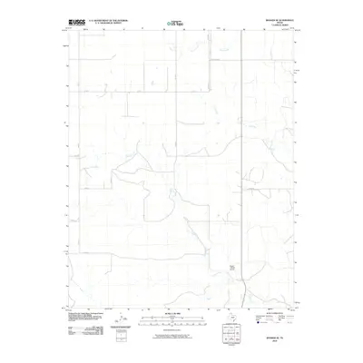
2010 Map of Booker SE
USGS Topo · Published 2010About this map
Gilhula Creek and First Creek define the drainage patterns of this corner of Lipscomb County, where the landscape is organized by an orderly grid of county roads and ranch lands. The most prominent private infrastructure is the Figure 1 Ranch Airport, situated south of Perry Rd and east of Gilhula Creek. This area of the Texas Panhandle remains dominated by large-scale ranching and agricultural operations, as evidenced by the namesake Uncle Sam Rd and various ranch access routes like Co Rd L and Co Rd 29. The terrain features several significant watercourses, including Kiowa Creek in the north and the Cottonwood Arroyo in the southwest, illustrating the subtle but essential topography that dictates the placement of roads like FM 2711 and the regional connectivity of the ranching economy.
Find a feature on this map
17 named features on this map. Tap any name to fly to it.
Don’t see what you’re looking for? This feature index may not catch every label — zoom into the map to look around manually.
Map Details
Editions of this 2010 Booker SE Map
This is the sole edition of this map. No revisions or reprints were ever made.
Other maps of this area

1954 · Perryton
USGS Topo · 1:250,000

1958 · Perryton
USGS Topo · 1:250,000

1972 · Barton Corners
USGS Topo · 1:24,000

1972 · Gaylord
USGS Topo · 1:24,000

1972 · Twin Grove
USGS Topo · 1:24,000

1972 · Booker SE
USGS Topo · 1:24,000

1973 · Booker
USGS Topo · 1:24,000

1973 · Booker SW
USGS Topo · 1:24,000

1973 · Lake Fryer
USGS Topo · 1:24,000
1973 · Lake Fryer NE
USGS Topo · 1:24,000