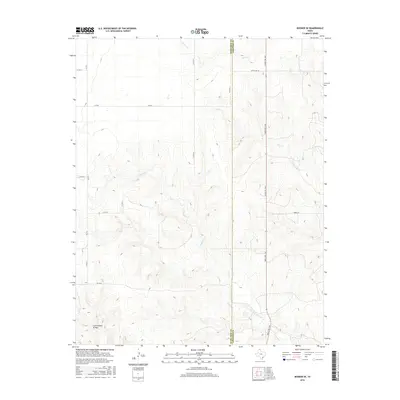
2016 Map of Booker SE
USGS Topo · Published 2016About this map
Ochiltree and Lipscomb Counties meet along a straight north-south line in this High Plains landscape, where the terrain is defined by the dendritic drainage patterns of several intermittent creeks. The eastern portion of the map is dominated by the course of Kiowa Cr, which flows toward the northeast corner, joined by the smaller First Cr. Further south, the map traces the meandering headwaters of Gilhula Cr, which carves a complex series of draws through the local topography. Human presence is marked primarily by a grid-like network of rural transit, including Uncle Sam Rd and Ranch Rd 1265. This area reflects the typical land use of the Texas Panhandle, where the high plains transition into the breaks of the North Canadian River watershed, as seen in the sharp incision of the Cottonwood Arroyo in the southwest.
Find a feature on this map
18 named features on this map. Tap any name to fly to it.
Don’t see what you’re looking for? This feature index may not catch every label — zoom into the map to look around manually.
Map Details
Editions of this 2016 Booker SE Map
This is the sole edition of this map. No revisions or reprints were ever made.
Other maps of this area

1954 · Perryton
USGS Topo · 1:250,000

1958 · Perryton
USGS Topo · 1:250,000

1972 · Barton Corners
USGS Topo · 1:24,000

1972 · Gaylord
USGS Topo · 1:24,000

1972 · Twin Grove
USGS Topo · 1:24,000

1972 · Booker SE
USGS Topo · 1:24,000

1973 · Booker
USGS Topo · 1:24,000

1973 · Booker SW
USGS Topo · 1:24,000

1973 · Lake Fryer
USGS Topo · 1:24,000
1973 · Lake Fryer NE
USGS Topo · 1:24,000