
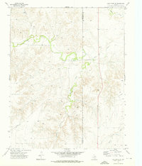
1972 Map of Booker SE
USGS Topo · Published 1976About this map
Oil and Gas Field operations dominate this 1970s landscape along the border of Ochiltree and Lipscomb counties. The map reveals a highly developed industrial network where an extensive Pipeline system and numerous wells intersect with the natural drainage of the High Plains. Water features provide the primary geographic structure, with Kiowa Creek cutting through the northern section and the winding course of Gilhula Creek carving deep relief into the central and southern terrain. Small-scale aviation and resource extraction are evident through the presence of Landing Strips and multiple Gravel Pits. Aside from these industrial markers, the area remains largely open, defined by its water sources like Arroyo Cottonwood, First Creek, and a solitary Spring, reflecting the era's focus on energy production in the Texas Panhandle.
Find a feature on this map
11 named features on this map. Tap any name to fly to it.
Don’t see what you’re looking for? This feature index may not catch every label — zoom into the map to look around manually.
Map Details
Editions of this 1972 Booker SE Map
This is the sole edition of this map. No revisions or reprints were ever made.
Other maps of this area

1954 · Perryton
USGS Topo · 1:250,000

1958 · Perryton
USGS Topo · 1:250,000

1972 · Barton Corners
USGS Topo · 1:24,000

1972 · Gaylord
USGS Topo · 1:24,000

1972 · Twin Grove
USGS Topo · 1:24,000

1973 · Booker
USGS Topo · 1:24,000

1973 · Booker SW
USGS Topo · 1:24,000

1973 · Lake Fryer
USGS Topo · 1:24,000
1973 · Lake Fryer NE
USGS Topo · 1:24,000

1973 · Huntoon
USGS Topo · 1:24,000