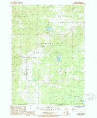
1987 Map of Boon
USGS Topo · Published 1988About this map
The Boon area of Wexford County is defined by its position within the Manistee National Forest, where high elevations and dense woodlands meet the pockets of agricultural clearing and glacial lake basins characteristic of this part of Michigan. The settlement of Meauwataka serves as a small hub in the northern section, positioned near Meauwataka Lake and the Colfax Twp Park. These natural features, alongside Woodward Lake and Altman Lake, illustrate a landscape shaped by water and timber, punctuated by several cemeteries and local gravel pits that indicate a rural economy tied to the land's raw materials.
Find a feature on this map
18 named features on this map. Tap any name to fly to it.
Don’t see what you’re looking for? This feature index may not catch every label — zoom into the map to look around manually.
Map Details
Editions of this 1987 Boon Map
This is the sole edition of this map. No revisions or reprints were ever made.
Other maps of this area

1933 · Luther NW
USGS Topo · 1:31,680

1954 · Traverse City
USGS Topo · 1:250,000

1956 · Mesick
USGS Topo · 1:62,500

1956 · Cadillac North
USGS Topo · 1:62,500

1957 · Cadillac South
USGS Topo · 1:62,500

1957 · Luther
USGS Topo · 1:62,500

1958 · Traverse City
USGS Topo · 1:250,000

1983 · Cadillac
USGS Topo · 1:100,000

1983 · Manton
USGS Topo · 1:25,000

1983 · Cadillac North
USGS Topo · 1:24,000