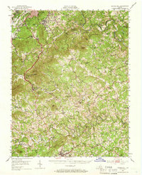
1951 Map of Boones Mill
USGS Topo · Published 1966About this map
Boones Mill sits at the heart of this Franklin County landscape, where the Blue Ridge Parkway winds through the prominent elevations of Cahas Mtn and Chestnut Ridge. This mid-century survey captures the rural character of the region as the Norfolk and Western and Virginian railroads served established communities like Wirtz and Starkey. The map reveals a high density of country churches and schools that anchored local life, including Boones Chapel, Mt Airy Ch, and the White Oak Grove Sch. Industrial and commercial history is visible through landmarks such as Piedmont Mill and Taylors Store. To the south, the early footprint of Rocky Mount is documented, showing the County Sch and the courthouse area before significant modern expansion, while the course of the Blackwater River and Maggodee Creek define the local drainage patterns and historic settlement sites.
Find a feature on this map
92 named features on this map. Tap any name to fly to it.
Don’t see what you’re looking for? This feature index may not catch every label — zoom into the map to look around manually.
Map Details
Editions of this 1951 Boones Mill Map

Other maps of this area

1890 · Roanoke
USGS Topo · 1:125,000

1890 · Christiansburg
USGS Topo · 1:125,000

1891 · Roanoke
USGS Topo · 1:125,000

1922 · Callands
USGS Topo · 1:48,000

1924 · Callands
USGS Topo · 1:62,500

1925 · Rocky Mount
USGS Topo · 1:48,000

1927 · Rocky Mount
USGS Topo · 1:62,500

1929 · Roanoke
USGS Topo · 1:48,000

1929 · Salem
USGS Topo · 1:48,000

1932 · Salem
USGS Topo · 1:62,500