
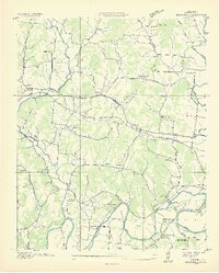
1936 Map of Boonshill
USGS Topo · Published 1936About this map
Elk River meanders through southern Lincoln County in this 1930s survey, defining a landscape of deep river bends including Hovey Bend, Caldwell Bend, and Pitts Bend. The rural economy of the era is evident in the Lincoln County Quarry and the Tep Co Power Plant near the settlement of Harms. An extensive network of country schools like Sheep Hill Sch and Hazeland Sch served the surrounding farming communities of Boonshill and East Cyruston. Local genealogy is well-documented through numerous family and church burial grounds, from the Sulphur Springs Cem in the north to the Phagan Cem near the river. Significant infrastructure including the Electric Trans Line and major thoroughfares like U S Highway No 64 illustrate the region's development during the Tennessee Valley Authority's early years of influence.
Find a feature on this map
60 named features on this map. Tap any name to fly to it.
Don’t see what you’re looking for? This feature index may not catch every label — zoom into the map to look around manually.
Map Details
Editions of this 1936 Boonshill Map
2 editions found
Other maps of this area

1936 · Cornersville
USGS Topo · 1:24,000

1936 · Taft
USGS Topo · 1:24,000

1936 · Belleville
USGS Topo · 1:24,000

1936 · Petersburg
USGS Topo · 1:24,000

1936 · Lincoln
USGS Topo · 1:24,000

1936 · Frankewing
USGS Topo · 1:24,000

1936 · Fayetteville
USGS Topo · 1:24,000

1936 · Dellrose
USGS Topo · 1:24,000

1944 · Shelbyville
USGS Topo · 1:100,000
1948 · Frankewing
USGS Topo · 1:24,000