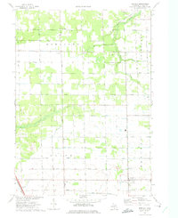
1972 Map of Borculo
USGS Topo · Published 1975About this map
The agricultural heart of Ottawa County is revealed in this 1970s study, defined by an intricate network of drainage systems and small settlements. The landscape around Borculo and Olive Center is heavily shaped by water management, featuring named channels like the Worley Drain and Vinans Drain that supported the region's farming economy. In the south, the Chesapeake and Ohio railroad cuts across the corner near Crisp, while the eastern edge is defined by the winding course of the Bass River and Bear Creek. This era shows a community rooted in local institutions, from the Christian Sch in the southeast to the Ottawa Ch and small family burial grounds like the West Olive Cem. The map captures a transition toward recreation with the inclusion of the Crestview Golf Course, yet the primary character remains one of rural townships—Robinson, Olive, Allendale, and Blendon—plotted along a rigid grid of street-named avenues.
Find a feature on this map
53 named features on this map. Tap any name to fly to it.
Don’t see what you’re looking for? This feature index may not catch every label — zoom into the map to look around manually.
Map Details
Editions of this 1972 Borculo Map
2 editions found
Other maps of this area

1929 · Holland
USGS Topo · 1:62,500

1930 · Muskegon
USGS Topo · 1:62,500

1932 · Holland
USGS Topo · 1:62,500

1936 · Muskegon
USGS Topo · 1:62,500

1945 · Ravenna
USGS Topo · 1:62,500

1954 · Milwaukee
USGS Topo · 1:250,000

1954 · Midland
USGS Topo · 1:250,000

1958 · Midland
USGS Topo · 1:250,000

1958 · Milwaukee
USGS Topo · 1:250,000

1958 · Allendale
USGS Topo · 1:24,000