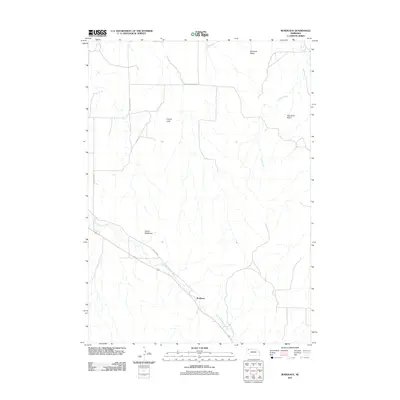
2011 Map of Bordeaux
USGS Topo · Published 2011About this map
Bordeaux serves as a central anchor in this rural Dawes County landscape, where the prairie begins to break into the dramatic rises of the Pine Ridge region. The area is defined by sharp topographic contrasts, from the winding path of Little Bordeaux Creek to the prominent natural monuments that guided early travelers. Local landmarks like Devils Backbone and Lovers Leap stand out against the drainage patterns of Cilek Creek, illustrating the geological complexity of the Nebraska panhandle. A network of local routes, including Redfern Rd and Beaver Valley Rd, connects the small settlement to the surrounding ranch land. The map also identifies distinctive formations such as Sheridan Gates and Squaw Tit Butte, which remain significant points of interest for those studying the physical history and land-use patterns of this corner of the state.
Find a feature on this map
11 named features on this map. Tap any name to fly to it.
Don’t see what you’re looking for? This feature index may not catch every label — zoom into the map to look around manually.
Map Details
Editions of this 2011 Bordeaux Map
This is the sole edition of this map. No revisions or reprints were ever made.
Other maps of this area

1955 · Alliance
USGS Topo · 1:250,000

1957 · Alliance
USGS Topo · 1:250,000

1958 · Alliance
USGS Topo · 1:250,000

1966 · Hay Springs
USGS Topo · 1:24,000

1966 · Chadron 3 NE
USGS Topo · 1:24,000

1969 · Beaver Wall
USGS Topo · 1:24,000

1969 · Chadron NE
USGS Topo · 1:24,000

1969 · Bordeaux
USGS Topo · 1:24,000
1969 · Whiteclay SW
USGS Topo · 1:24,000

1970 · Chadron 3 NW
USGS Topo · 1:24,000