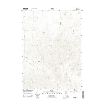
2014 Map of Bordeaux
USGS Topo · Published 2014About this map
Bordeaux sits along the southern edge of this landscape, positioned where Us-20 and Redfern Rd meet near the banks of Little Bordeaux Cr. The area is defined by sharp topographic transitions, most notably the county line between Dawes Co and Sheridan Co which cuts vertically through the complex terrain. Prominent landmarks such as Sheridan Gates, Lovers Leap, and Devils Backbone suggest a geography shaped by distinct rock formations and high ridges, while Squaw Tit Butte rises in the northeast corner near Cilek Cr. A network of rural connectors, including Sheridan Gates Rd and Beaver Valley Rd, provides access across the northern valleys. This 2014 survey documents the modern layout of these remote cattle-country routes and the drainage patterns of the Beaver Cr watershed before they cross into the neighboring high plains.
Find a feature on this map
15 named features on this map. Tap any name to fly to it.
Don’t see what you’re looking for? This feature index may not catch every label — zoom into the map to look around manually.
Map Details
Editions of this 2014 Bordeaux Map
This is the sole edition of this map. No revisions or reprints were ever made.
Other maps of this area

1955 · Alliance
USGS Topo · 1:250,000

1957 · Alliance
USGS Topo · 1:250,000

1958 · Alliance
USGS Topo · 1:250,000

1966 · Hay Springs
USGS Topo · 1:24,000

1966 · Chadron 3 NE
USGS Topo · 1:24,000

1969 · Beaver Wall
USGS Topo · 1:24,000

1969 · Chadron NE
USGS Topo · 1:24,000

1969 · Bordeaux
USGS Topo · 1:24,000
1969 · Whiteclay SW
USGS Topo · 1:24,000

1970 · Chadron 3 NW
USGS Topo · 1:24,000