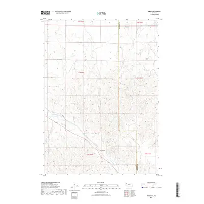
2017 Map of Bordeaux
USGS Topo · Published 2017About this map
Bordeaux and the surrounding high plains of Dawes County are defined by a complex network of drainages and dramatic geological rises. The settlement of Bordeaux sits along the banks of Little Bordeaux Cr, which winds through the southern portion of the area before meeting Bordeaux Cr. To the north, the landscape is punctuated by significant landmarks including Lovers Leap and Squaw Tit Butte, which rise above the surrounding terrain near the Sheridan County line. This area shows a sparse settlement pattern connected by rural routes such as Sheridan Gates Rd and Beaver Valley RD. The presence of named features like Devils Backbone indicates a topography of sharp ridges and eroded breaks, typical of this portion of Nebraska where the high plains begin to fracture into more varied relief. Further north, Sheridan Gates provides a geographic waypoint near the northern limit of the survey.
Find a feature on this map
19 named features on this map. Tap any name to fly to it.
Don’t see what you’re looking for? This feature index may not catch every label — zoom into the map to look around manually.
Map Details
Editions of this 2017 Bordeaux Map
This is the sole edition of this map. No revisions or reprints were ever made.
Other maps of this area

1955 · Alliance
USGS Topo · 1:250,000

1957 · Alliance
USGS Topo · 1:250,000

1958 · Alliance
USGS Topo · 1:250,000

1966 · Hay Springs
USGS Topo · 1:24,000

1966 · Chadron 3 NE
USGS Topo · 1:24,000

1969 · Beaver Wall
USGS Topo · 1:24,000

1969 · Chadron NE
USGS Topo · 1:24,000

1969 · Bordeaux
USGS Topo · 1:24,000
1969 · Whiteclay SW
USGS Topo · 1:24,000

1970 · Chadron 3 NW
USGS Topo · 1:24,000