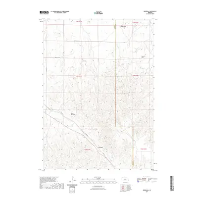
2021 Map of Bordeaux
USGS Topo · Published 2021About this map
Bordeaux serves as a central point in this part of Dawes County, where the modern Cowboy Trl and Redfern Rd follow a diagonal path through the landscape. The terrain is marked by distinctive geological formations such as Lovers Leap, Devils Backbone, and Squaw Tit Butte, which define the local horizon and historically served as significant landmarks for travelers and residents. The map captures the interface between these natural features and the established rural road network, including Sheridan Gates Rd and Beaver Valley Rd. Drainage for the region is provided by Little Bordeaux Cr and Cilek Cr, which wind through the township divisions of T33N R47W and its neighbors. The placement of the small settlement of Sheridan Gates at the northern boundary illustrates the persistent but sparse nature of human habitation in this high plains environment.
Find a feature on this map
19 named features on this map. Tap any name to fly to it.
Don’t see what you’re looking for? This feature index may not catch every label — zoom into the map to look around manually.
Map Details
Editions of this 2021 Bordeaux Map
This is the sole edition of this map. No revisions or reprints were ever made.
Other maps of this area

1955 · Alliance
USGS Topo · 1:250,000

1957 · Alliance
USGS Topo · 1:250,000

1958 · Alliance
USGS Topo · 1:250,000

1966 · Hay Springs
USGS Topo · 1:24,000

1966 · Chadron 3 NE
USGS Topo · 1:24,000

1969 · Beaver Wall
USGS Topo · 1:24,000

1969 · Chadron NE
USGS Topo · 1:24,000

1969 · Bordeaux
USGS Topo · 1:24,000
1969 · Whiteclay SW
USGS Topo · 1:24,000

1970 · Chadron 3 NW
USGS Topo · 1:24,000