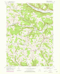
1953 Map of Borden
USGS Topo · Published 1978About this map
Canisteo River flows across the northern reaches of this Steuben County landscape, where the Conrail line skirts the valley near Derby Switch. The terrain is defined by a dense network of hills and hollows, often named for early local families, including Symonds Hill, Earl Beatty Hill, and Barney Hill. This mid-century view, updated with 1970s woodland revisions, reveals a rural economy centered on small crossroads like Borden and South Addison.
Find a feature on this map
43 named features on this map. Tap any name to fly to it.
Don’t see what you’re looking for? This feature index may not catch every label — zoom into the map to look around manually.
Map Details
Editions of this 1953 Borden Map
Other maps of this area

1900 · Tioga
USGS Topo · 1:62,500

1900 · Elkland
USGS Topo · 1:62,500

1902 · Tioga
USGS Topo · 1:62,500

1914 · Corning
USGS Topo · 1:62,500

1924 · Woodhull
USGS Topo · 1:48,000

1926 · Woodhull
USGS Topo · 1:62,500

1944 · Woodhull
USGS Topo · 1:62,500

1944 · Corning
USGS Topo · 1:62,500

1950 · Elmira
USGS Topo · 1:250,000

1953 · Campbell
USGS Topo · 1:24,000