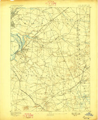
1893 Map of Bordentown
USGS Topo · Published 1898About this map
The Pennsylvania Railroad corridor and the Delaware River waterfront anchor this late 19th-century survey of Central New Jersey. Centered on the historic river town of Bordentown, the map details a landscape defined by industrial expansion and established agricultural townships. The riverbank features Duck Island and Fieldsboro, while the interior is a dense network of hamlets including Hamilton Square, Crosswicks, and Recklesstown.
Find a feature on this map
82 named features on this map. Tap any name to fly to it.
Don’t see what you’re looking for? This feature index may not catch every label — zoom into the map to look around manually.
Map Details
Editions of this 1893 Bordentown Map
3 editions found

Other maps of this area

1884 · Whitings
USGS Topo · 1:62,500

1888 · Bordentown
USGS Topo · 1:62,500

1888 · Pemberton
USGS Topo · 1:62,500

1888 · New Brunswick
USGS Topo · 1:62,500

1888 · Mount Holly
USGS Topo · 1:62,500

1888 · Princeton
USGS Topo · 1:62,500

1888 · Cassville
USGS Topo · 1:62,500

1888 · Whitings
USGS Topo · 1:62,500

1890 · Lambertville
USGS Topo · 1:62,500

1890 · Burlington
USGS Topo · 1:62,500