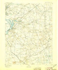
1893 Map of Bordentown
USGS Topo · Published 1905About this map
The Bordentown waterfront along the New Jersey Pennsylvania Boundary Line serves as a major logistical hub in the late nineteenth century. Rail infrastructure dominates the landscape, with the Pennsylvania Railroad (Amboy Div.) and the Trenton Branch Railroad (Amboy Div. P.R.R.) converging near Duck Island. Away from the river, the interior of Burlington and Monmouth counties is defined by a dense network of agricultural settlements and mill towns. Small communities like Recklesstown, Allentown, and Imlaystown are connected by winding roads that follow the contours of Crosswicks Creek and Doctor Creek. The presence of many family-named locales, such as Arneytown and Ellisdale, alongside significant estates like Cranberry Hall, reflects a well-established rural social structure before twentieth-century suburbanization reshaped the region.
Find a feature on this map
82 named features on this map. Tap any name to fly to it.
Don’t see what you’re looking for? This feature index may not catch every label — zoom into the map to look around manually.
Map Details
Editions of this 1893 Bordentown Map
3 editions found

Other maps of this area

1884 · Whitings
USGS Topo · 1:62,500

1888 · Bordentown
USGS Topo · 1:62,500

1888 · Pemberton
USGS Topo · 1:62,500

1888 · New Brunswick
USGS Topo · 1:62,500

1888 · Mount Holly
USGS Topo · 1:62,500

1888 · Princeton
USGS Topo · 1:62,500

1888 · Cassville
USGS Topo · 1:62,500

1888 · Whitings
USGS Topo · 1:62,500

1890 · Lambertville
USGS Topo · 1:62,500

1890 · Burlington
USGS Topo · 1:62,500