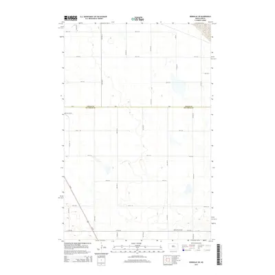
2014 Map of Bordulac SW
USGS Topo · Published 2014About this map
Bennetts Coulee snakes through the southern reaches of this North Dakota landscape, where the prairie of Stutsman and Foster Counties is defined by a rigorous section-line road grid. The intersection of Us-281 and ND-9 forms the primary transit artery for this agricultural region, providing a direct link between local farmsteads and larger regional centers. This 2014 survey captures a moment when the rural infrastructure remains centered on the land, anchored by features like Reimers Airport, located along the western boundary. The terrain is dotted with numerous small prairie potholes and wetlands, illustrating the glacial legacy of the Drift Prairie. These depressions, interspersed among the precisely surveyed avenues and streets from 3rd St SE down to 11th St SE, underscore the persistence of the natural drainage patterns even in a highly organized rural landscape.
Find a feature on this map
21 named features on this map. Tap any name to fly to it.
Don’t see what you’re looking for? This feature index may not catch every label — zoom into the map to look around manually.
Map Details
Editions of this 2014 Bordulac SW Map
This is the sole edition of this map. No revisions or reprints were ever made.
Other maps of this area

1900 · Pingree
USGS Topo · 1:125,000

1900 · Pingree
USGS Topo · 1:62,500

1948 · Carrington
USGS Topo · 1:62,500

1950 · Carrington East
USGS Topo · 1:24,000

1950 · Melville
USGS Topo · 1:24,000

1951 · Bordulac NE
USGS Topo · 1:24,000

1951 · Arrowwood Lake
USGS Topo · 1:24,000

1951 · Pingree
USGS Topo · 1:24,000

1951 · Bordulac SW
USGS Topo · 1:24,000
1951 · Bordulac
USGS Topo · 1:24,000