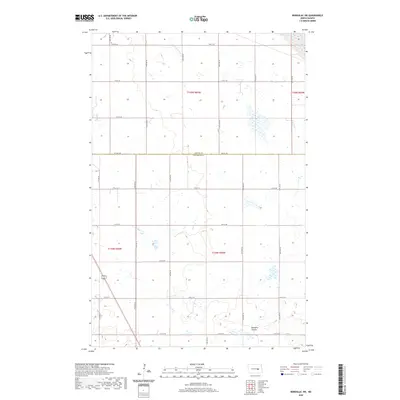
2020 Map of Bordulac SW
USGS Topo · Published 2020About this map
Bennetts Coulee winds through the southern reaches of this landscape, carving a distinct hydrological path across the prairie. The map captures the meeting of Foster Co and Stutsman Co, showing a terrain defined by the Public Land Survey System. A rigid grid of rural roads, including 3rd St Se and 11th St Se, facilitates movement between sections, while north-south thoroughfares like 71st Ave Se and 78th Ave Se establish the regional transit framework. Numerous small wetlands and depressions characteristic of the North Dakota pothole region dot the surface, reflecting the natural drainage patterns of the high plains before they converge into named coulees. This survey provides a clear view of the agricultural section lines and township boundaries that have organized this part of the state for generations.
Find a feature on this map
23 named features on this map. Tap any name to fly to it.
Don’t see what you’re looking for? This feature index may not catch every label — zoom into the map to look around manually.
Map Details
Editions of this 2020 Bordulac SW Map
This is the sole edition of this map. No revisions or reprints were ever made.
Other maps of this area

1900 · Pingree
USGS Topo · 1:125,000

1900 · Pingree
USGS Topo · 1:62,500

1948 · Carrington
USGS Topo · 1:62,500

1950 · Carrington East
USGS Topo · 1:24,000

1950 · Melville
USGS Topo · 1:24,000

1951 · Bordulac NE
USGS Topo · 1:24,000

1951 · Arrowwood Lake
USGS Topo · 1:24,000

1951 · Pingree
USGS Topo · 1:24,000

1951 · Bordulac SW
USGS Topo · 1:24,000
1951 · Bordulac
USGS Topo · 1:24,000