
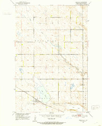
1951 Map of Bordulac SW
USGS Topo · Published 1953About this map
The rolling plains of Stutsman County are defined by a complex network of glacial depressions and early rail infrastructure in the early 1950s. The northern edge of the map follows the line of the Minneapolis St Paul and Sault Ste Marie railroad, which served the small loading point at Millers Spur near the shores of Dry Lake. To the southwest, the Northern Pacific line cuts diagonally across the prairie, passing through rural landscapes marked by long-established survey townships like Bucephalia, Bordulac, and Edmunds. Local education and social life centered on sites like the Arrowwood Sch, while the presence of Bennetts along the Coulee in the southeast corner indicates the scattered nature of settlement during this era of prairie agriculture. The map captures the region's topography in fine detail, showing the numerous small basins and prairie potholes that characterize this portion of the Missouri River Basin.
Find a feature on this map
12 named features on this map. Tap any name to fly to it.
Don’t see what you’re looking for? This feature index may not catch every label — zoom into the map to look around manually.
Map Details
Editions of this 1951 Bordulac SW Map
This is the sole edition of this map. No revisions or reprints were ever made.
Other maps of this area

1900 · Pingree
USGS Topo · 1:125,000

1900 · Pingree
USGS Topo · 1:62,500

1948 · Carrington
USGS Topo · 1:62,500

1950 · Carrington East
USGS Topo · 1:24,000

1950 · Melville
USGS Topo · 1:24,000

1951 · Bordulac NE
USGS Topo · 1:24,000

1951 · Arrowwood Lake
USGS Topo · 1:24,000

1951 · Pingree
USGS Topo · 1:24,000
1951 · Bordulac
USGS Topo · 1:24,000

1952 · Jim Lake
USGS Topo · 1:24,000