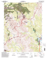
1994 Map of Boreas Pass
USGS Topo · Published 1998About this map
Parkville and Dyersville anchor this high-altitude landscape along the Continental Divide, where the mining history of the late nineteenth century is still etched into the terrain. The map records a network of early transit routes, including the Old French Pass Toll Road and the Boreas Pass Road, which once served as vital arteries for silver and gold mining operations. Evidence of industrial ambition is found in the scattered remains of the Lincoln Mine, Gold Bell Mine, and Warrior Mark Mine. Cultural landmarks like the Masonic Monument and Bakers Tank offer specific touchpoints for local historians and genealogists. Residential history is preserved through the Schattinger Homestead and Volz Homestead, situated near the headwaters of Michigan Creek. This survey details the overlap of the Arapaho and Pike National Forests, marking a transition from early extraction to modern recreational use via the Colorado Trail.
Find a feature on this map
61 named features on this map. Tap any name to fly to it.
Don’t see what you’re looking for? This feature index may not catch every label — zoom into the map to look around manually.
Map Details
Editions of this 1994 Boreas Pass Map
This is the sole edition of this map. No revisions or reprints were ever made.
Other maps of this area

1889 · Leadville
USGS Topo · 1:125,000

1891 · Leadville
USGS Topo · 1:125,000

1924 · Montezuma
USGS Topo · 1:62,500

1926 · Montezuma
USGS Topo · 1:62,500

1929 · Dillon
USGS Topo · 1:62,500

1933 · Montezuma
USGS Topo · 1:62,500

1934 · Climax
USGS Topo · 1:48,000

1934 · Dillon
USGS Topo · 1:62,500

1937 · Como
USGS Topo · 1:62,500

1938 · Mt. Lincoln
USGS Topo · 1:48,000