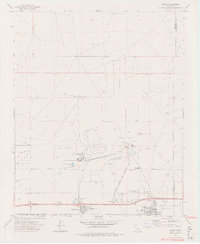
1973 Map of Boron
USGS Topo · Published 1976About this map
Industrial extraction dominates this landscape on the boundary of Kern and San Bernardino Counties, where an enormous Open Pit Mine and extensive Mine Dump define the terrain north of the town center. The local economy and infrastructure are clearly built around this mineral wealth, with a large Conveyor system, tailings, and Sewage Disposal Ponds supporting the operation. Transportation is anchored by the Atchison Topeka and Santa Fe railroad, which runs parallel to the Aqueduct and major thoroughfares like 20 Mule Team Road.
Find a feature on this map
29 named features on this map. Tap any name to fly to it.
Don’t see what you’re looking for? This feature index may not catch every label — zoom into the map to look around manually.
Map Details
Editions of this 1973 Boron Map
2 editions found
Other maps of this area

1915 · Searles Lake
USGS Topo · 1:250,000

1937 · Kramer
USGS Topo · 1:48,000

1937 · Rogers Lake
USGS Topo · 1:48,000

1942 · Kramer
USGS Topo · 1:62,500

1942 · Rogers Lake
USGS Topo · 1:62,500

1943 · Castle Butte
USGS Topo · 1:62,500

1947 · Castle Butte
USGS Topo · 1:50,000

1947 · Kramer
USGS Topo · 1:24,000

1947 · Johannesburg SE
USGS Topo · 1:25,000

1947 · Rich
USGS Topo · 1:24,000