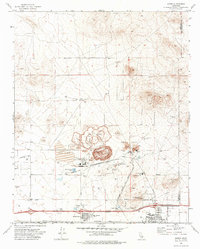
1973 Map of Boron
USGS Topo · Published 1976About this map
Industrial mineral extraction dominates the landscape at this Mojave Desert site, most notably via the massive Open Pit Mine and its accompanying Mine Dump. The map reveals the infrastructure required for such large-scale operations, including an extensive Conveyor system, multiple Tailings Ponds, and the Atchison Topeka and Santa Fe railroad line. Settlement is concentrated in Boron and Desert Lake, where local amenities like West Boron Sch and a High Sch serve the mining community.
Find a feature on this map
30 named features on this map. Tap any name to fly to it.
Don’t see what you’re looking for? This feature index may not catch every label — zoom into the map to look around manually.
Map Details
Editions of this 1973 Boron Map
2 editions found
Other maps of this area

1915 · Searles Lake
USGS Topo · 1:250,000

1937 · Kramer
USGS Topo · 1:48,000

1937 · Rogers Lake
USGS Topo · 1:48,000

1942 · Kramer
USGS Topo · 1:62,500

1942 · Rogers Lake
USGS Topo · 1:62,500

1943 · Castle Butte
USGS Topo · 1:62,500

1947 · Castle Butte
USGS Topo · 1:50,000

1947 · Kramer
USGS Topo · 1:24,000

1947 · Johannesburg SE
USGS Topo · 1:25,000

1947 · Rich
USGS Topo · 1:24,000