1967 Map of Boscobel
USGS Topo · Published 1970About this map
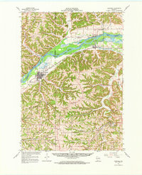
Wisconsin River dominates the center of this 1960s landscape, winding past a series of riverbed islands such as Coumbe Island and Big Island. Along its southern bank, the city of Boscobel serves as a regional hub, connected to the wider world by the Chicago Milwaukee St Paul and Pacific railroad. The map reveals a deeply etched topography of hollows and ridges, such as Oak Ridge and Adkins Ridge, where numerous small quarries and sandpits indicate the local extraction economy of the mid-20th century.
Find a feature on this map
75 named features on this map. Tap any name to fly to it.
Don’t see what you’re looking for? This feature index may not catch every label — zoom into the map to look around manually.
Map Details
Editions of this 1967 Boscobel Map
This is the sole edition of this map. No revisions or reprints were ever made.
Other maps of this area

1900 · Lancaster
USGS Topo · 1:125,000

1902 · Mineral Point
USGS Topo · 1:125,000

1904 · Lancaster
USGS Topo · 1:125,000

1905 · Richland Center
USGS Topo · 1:125,000

1908 · Lancaster
USGS Topo · 1:125,000

1924 · Gays Mills
USGS Topo · 1:62,500

1926 · Gays Mills
USGS Topo · 1:62,500

1926 · Wauzeka
USGS Topo · 1:62,500

1933 · Boaz
USGS Topo · 1:62,500

1933 · Boscobel
USGS Topo · 1:62,500