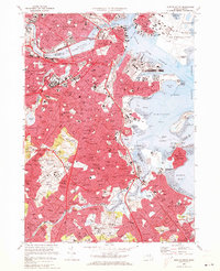
1970 Map of Boston South
USGS Topo · Published 1973About this map
Beacon Hill and the Boston Common stand at the heart of this urban landscape during a period of significant 20th-century density. The map details the complex shoreline where the Charles River Basin meets the Boston Inner Harbor, showcasing the massive industrial footprint of the Logan International Airport and the US Naval Res dry docks. Moving inland, the dense residential neighborhoods of South Boston, Roxbury, and Dorchester are interwoven with transit corridors like the Penn Central and Mbta lines.
Find a feature on this map
126 named features on this map. Tap any name to fly to it.
Don’t see what you’re looking for? This feature index may not catch every label — zoom into the map to look around manually.
Map Details
Editions of this 1970 Boston South Map
2 editions found
Other maps of this area

1885 · Abington
USGS Topo · 1:62,500

1886 · Dedham
USGS Topo · 1:62,500

1888 · Abington
USGS Topo · 1:62,500

1892 · Boston Bay
USGS Topo · 1:62,500

1893 · Abington
USGS Topo · 1:62,500

1893 · Boston
USGS Topo · 1:62,500

1894 · Dedham
USGS Topo · 1:62,500

1903 · Boston
USGS Topo · 1:62,500

1903 · Boston Bay
USGS Topo · 1:62,500

1919 · Dedham
USGS Topo · 1:62,500